There is so much in the background about maps made in this era that we won’t delve into details, such as the conversion of coordinates to GPS or the theory of longitude and latitude here. [See notes for more resources.] However, we have several maps of different scales used by Canadians during the First World War in our collections.
When researching individual soldiers, coordinates may indicate where the man was buried, such as “Exhumed from: Sheet 44c.T.1c.1.6” What does all that mean?
The Basics
Maps of various scales were titled with a place name and sheet reference, such as our map of Vimy. To maintain a reference to the larger picture of the ground, maps were divided into sheets, then subdivided into sectors NW, NE, SE and SW.
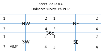
Each numbered sector is divided into rectangular quadrants 6,000 x 5,000 yards and lettered A-X that spread across adjacent maps. Other information on the margins includes when the base map was made, when the trench overlays were updated, its relation to adjoining maps, and a legend of map symbols.
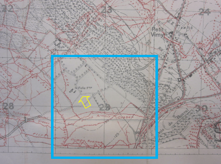
The Orange rectangle highlights a portion of S which consists of 36
squares that extend to the next map.
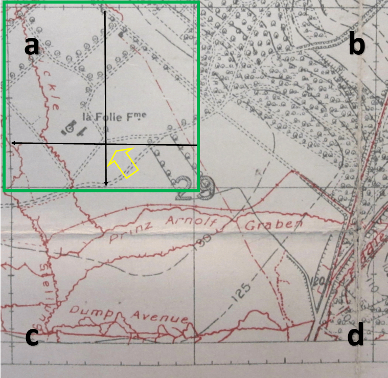
The Yellow arrow points to a trail junction near La Folie Farm.
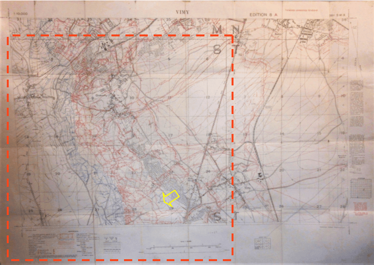
Highlighted in Blue is sq. 29, in rectangle S on Sheet 36c 3, which is
1,000 x 1,000 yards.
Each numbered square is subdivided by four squares a, b, c and d. The Yellow arrow points to the trail junction near La Folie Farm, which was the main objective of the 2nd Canadian Mounted Rifles from the Okanagan on April 9, 1917.
Vimy – Sheet 36c SW 3 – Edition 8 A – Ordnance Survey Feb. 1917 –
Trenches corrected to 10.2.17 – Scale: 1/10,000 yards
Highlighted in Green is sq. a, which is 500 x 500 yards.
Each square is subdivided by ten hash marks per side for 50 x 50 yards. The 4-digit coordinates for the junction, to the closest cross point marked in Black, is 51.25, meaning five marks from left to right, then 2.5 marks from the bottom to the top of the sq. [“In the door and up the stairs.”]
In full: VIMY Sh 36c NW S.29.a.52.25
As mentioned, there is so much more to know, including how to match war diary coordinates to Google Earth and GPS. In a comment posted on March 7, 2016, by WhiteStarLine on GreatWarForum.org, he states:
“The ultimate aim of the WW1 cartographer was to produce a product of such accuracy that would allow, as an example, a WW1 gunner to fire on a reported enemy position using predicted fire. In other words, if an observer saw a target on the cross roads, an artillery position many kilometres away could use the map with such confidence that first rounds would land on that position. Post-war analysis revealed how successful this really was.
The aim of modern enthusiasts . . . is to come up with a body of work that enables a modern user to research a WW1 location from a WW1 trench map and stand on the same spot using modern techniques such as Google maps and GPS. We did this in 2012, following my grandfather’s brigade’s footsteps.”
In-depth online resources:
McMaster University FWW military maps and aerial photography library
https://library.mcmaster.ca/maps/index-wwi-trench-maps-and-aerial-photographs
http://lt1.mcmaster.ca/ww1/wrz4mp.php?grid=51b
Utilizing trench maps by military and family history blog
https://militaryandfamilyhistory.blog/2018/06/05/utilizing-trench-maps-part-1-digitized-and-offline-resources/
https://militaryandfamilyhistory.blog/2018/06/13/utilizing-trench-maps-part-2-map-references-case-studies/
Forum posting at Wartimes.ca
https://www.wartimes.ca/forums/viewtopic.php?t=12
Trench Mapper
https://www.westernfrontassociation.com/world-war-i-articles/trenchmapper-by-the-western-front-association/how-to-find-a-point-on-a-trench-map/